The chart production process is different for bathymetry and backscatter. It even requires some different commands for Resonor Simrad data.
Bathymetry
You might have noticed while making your temporary dtm that it reaches a large size as your looking at a big dataset. In such a case it is better to use a larger pixel size (as it is only used for cleaning interpretation this may not harm to much), or decide to partition the dataset in smaller areas. The latter is more feasible cause the file size is limited though you' ll keep good grid resolution (e.g. 1x1m). This is done by making so called Box headers.My approach is to first make a mapsheet of the complete area and create the box headers (=smaller areas). I decide to use the navigation track to get a feeling of the area's of interest, so the pixel size of the mapsheet won't dominate and subsequently the file size wont exceed. (I assume you already have the boundaries of the complete data set, other wise:
- getBounds merged/sub_dir/*merged
)
I) make_blank
- make_blank overview -boundsof ../merged/sub_dir/*merged
The program asks for the data type, either floating point or 8bit. A floating point data type is used for bathymetry. A 8bit number ranges from 0 to 255 (28=256) and are used to represent the grey level values for backscatter data.
For our case choose floating point array (2).
Use a fair big pixel size like 25 or so.
II) Box.header Now select your box headers and view the navigation track:
- jview overview.blank -pickrot -navlook ../decnav/sub_dir/*decnav
- -pickrot
pick and rotate a boxheader
- -navlook
look at the navigation track and direct to the path of the decnav files
To enable the pickrot function you first need to have a subarea opened, zo just zoom in somewhere. With the right mouse button you can place the box. Scale it with the left and right arrow keys and rotate it with '+' and '-'. Choose a new box with 'n', exit when your done.
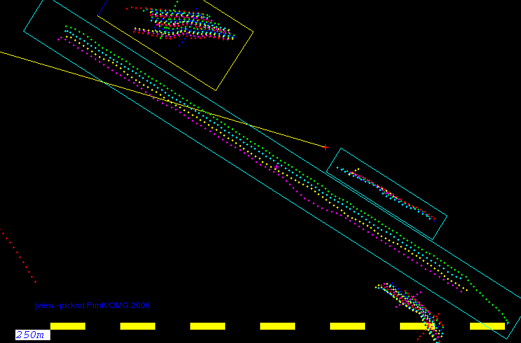
If you look at the list now you'll see it created several Box.headers:
-
Box.header0
Box.header1
etc etc..
Create dtm's of each area in the box header. We do this with the make_blank, tor4, weigh_grid and addSUN functions.
- make_blank dtm_name -area Box.headerx
- -area
with -area your using the boundaries, ellipsoid and projection of the specified box header. You may want to take notes which box headers belong to which area, but you can also rename them if you wish.
If you want to change a projection, ellipsoid or whatever, use the edhead command (edit header):
- edhead -show Box.headerx
The -show option displays the parameters of the Box.header. Without specifying the -show option you'll reach a menu that enables you to modify the parameters. You can also use edhead for r4-, sun and 8bit files.
III)r4 weigh_grid addSUN Create the r4:
- tor4 dtm_name
....and fill it with bathy data:
- weigh_grid -beamwidth x.x -custom_weight a_beam_weightfile dtm_name ../merged/sub_dir/*merged
recall:
- -beamwidth
takes the beam dimensions into account
- -custom_weight
use a specified weight file (of the beams! NOT the weight file generated by the tor4 function.)
Get a sun illuminated to:
- addSUN dtm_name
This default uses 315 degrees azimuth, you can change it with the -azi xxx option.
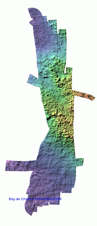
Look at the results so far:
- jview dtm_name.r4 dtm_name.sun_315
To reach a better contrast stretch the color range over the color bar. Hit 'h' for histogram while pointing with the mouse on the mapsheet. You'll notice the histogram in the color bar, stretch it with the left an right mouse buttons. Make notes of the greylevel values (only for sun image). Do the addSUN again and provide the greylevel range:
- addSUN -range xxx xxx dtm_name
- r4to8bit dtm_name
It creates dtm_name.8bit. NOTE, use the command without the .r4 extension!
- mix_ci -mask dtm_name.sun_315 -ignore 255 -c dtm_name.8bit -i dtm_name.sun_315 -ppm -m output_name
- -mask
provide the sun file as mask. All data outside the mask gets value 0 (=white).
- -ignore 255
gaps in the data will be filled black
- -c dtm_name.8bit
the .8bit dtm file provides the colors
- -i dtm_name.sun_315
the .sun file provides intensity values
- -ppm
output it as a .ppm-file
- -m
outputname
View the result with:
- xv outputname.ppm
V)adding contours
Add som contours with the following commands.
First smooth the grid to achieve smooth contours:
You can view the result with:
With the import command you can make an image of the dtm with contours, for example:
First smooth the grid to achieve smooth contours:
- decr4 -count 5 -in dtm_name.r4 -out temp.dec.r4
- -count
it takes 5 pixels to create a single contour value.
- contgrid temp.dec.r4 dtm_name.cont
You can view the result with:
- jview dtm_name.8bit -vectbin dtm_name.cont
With the import command you can make an image of the dtm with contours, for example:
- import dtm_contour.gif
Get a example of a script here. Remember, it may need some tweaking from yourself.
Backscatter
UNDERCONSTRUCTION!!!!
I have'nt got my hands dirty on backscatter too much, so this section is a long term plan. Though if your really desperate you can find some notes here.
Reson
Simrad
back 2) Gridding and cleaning
Home
__________________________
Last modified: 23-07-'06, Pim.
Last modified: 23-07-'06, Pim.